


-
森林可燃物是林火发生的基础,可燃物类型及其载量影响火强度和蔓延速度。减少林内可燃物载量是降低林火发生的重要途径,也是林火管理的主要组成部分。可燃物处理方法主要有机械清理和计划火烧[1]。其中计划火烧(prescribed burning)是在人为控制下,有计划地利用低强度火清理林内可燃物,降低林火发生可能[2]。与其他方式相比,计划火烧不但可有效清除地表可燃物,而且经济成本低,还具有保护生物多样性和维持森林生产力的作用[3-4],是当前应用最广泛的可燃物管理措施。我国针对计划火烧提出了“物候点烧”、“跟雪点烧”等多种点烧方法,在西南、东北及内蒙林区得到广泛应用[5]。大兴安岭地区的森林可燃物分解慢,长期积累大量的地表可燃物,容易发生森林火灾[6]。通过计划火烧措施可以降低地表可燃物载量,减少林火发生,有利于森林生态系统的稳定。计划火烧是大兴安岭地区一项重要的可燃物处理措施,但定量评估计划火烧对森林防火的作用的相关研究还很少。刘志华等利用LANDIS模型模拟了计划火烧处理对呼中地区潜在的火发生影响,通过计划火烧进行可燃物处理会在一定程度上减少过火面积[7]。赵彬清等研究了计划火烧前后落叶松林土壤微生物、碳氮及湿度温度的变化,认为计划火烧不会导致土壤呼吸增加,为计划火烧的实施提供了理论基础[8]。
林分类型、地理环境等因素决定可燃物处理的方式方法[9]。计划火烧可用于清除细小可燃物,降低可燃物载量,在草甸及灌木区域使用广泛[10]。机械处理用于清除粗可燃物及空中可燃物,在落叶松林中与计划火烧结合使用,可有效降低地表可燃物及空中可燃物,减少地表火和树冠火发生的可能,降低火强度。可燃物处理的季节及时间对处理效果也有影响。在秋季进行计划火烧更能有效减少可燃物积累,降低林火的发生[11]。根据可燃物累积及分解过程,周期性进行低强度的计划火烧,可以调控森林地表可燃物载量[12-13]。大兴安岭地区草本灌木较多,在火险期易燃烧,蔓延速度快,是火灾的发源地。因此,每年定期在火险期前对沟塘草甸进行火烧处理,以降低地表可燃物载量,减少林火的发生,现已成为大兴安岭实施可燃物管理的有效措施。
基于森林资源和火烧安全方面的考虑,野外火烧实验的尺度一般比较小,只通过野外火烧实验难以定量评估林火管理措施对森林燃烧性的影响,因此,需要从景观尺度上模拟各种可燃物管理情景下的林火行为[14]。目前有一些模型可以模拟不同可燃物和天气条件下的森林燃烧过程。BEHAVE模型可以模拟可燃物对火行为影响[15],FOFEM模型可模拟火烧过程中树木死亡、可燃物消耗量等过程[16],但这些模型不能模拟火发生及蔓延过程。SIMMPPLE模型可从空间尺度模拟火蔓延过程,但不能直接模拟计划火烧过程[17]。LANDIS模型可以模拟可燃物的累积和分解过程,也可以在景观尺度上模拟火干扰的影响[18]。燃烧概率(BURN-P3)模型主要是用于评估景观尺度上的森林燃烧概率[19]。该模型结合气候、植被和地形等条件,可以模拟不同情景下的火发生及蔓延过程[20-21]。模型以年为步长进行迭代循环,迭代次数根据研究区面积大小、景观结构组成和火动态确定。对于每场火要模拟从点燃、蔓延到熄灭整个过程。首先要根据研究区的火发生历史统计数据确定不同季节的火发生概率图。模型将根据每个栅格的火发生概率、可燃物类型和火天气判断火是否可以被点燃以及点燃位置。如果确定火被点燃,就根据气象和火险指数利用Prometheus火增长模型模拟这场火的蔓延过程。通过整个火场的模拟过程就可以获得每场火发生位置和过火面积、火强度、树冠火发生比例等火场信息和火行为信息。同一迭代过程中不会出现重复火烧的格点,根据每个格点在所有迭代次数中的重复火烧次数计算得到燃烧概率。苗庆林等[22]通过对1991—2010年大兴安岭地区的燃烧概率进行模拟分析,验证了BURN-P3模型在我国大兴安岭地区的适用性,并模拟了未来不同气候情景下的森林燃烧性变化。
本研究利用BURN-P3模型模拟计划火烧前后两种情景下的森林燃烧概率,从燃烧概率、火强度、蔓延速度及树冠火发生比例等方面评估火险期前的计划火烧措施对一个区域森林燃烧性的影响。
-
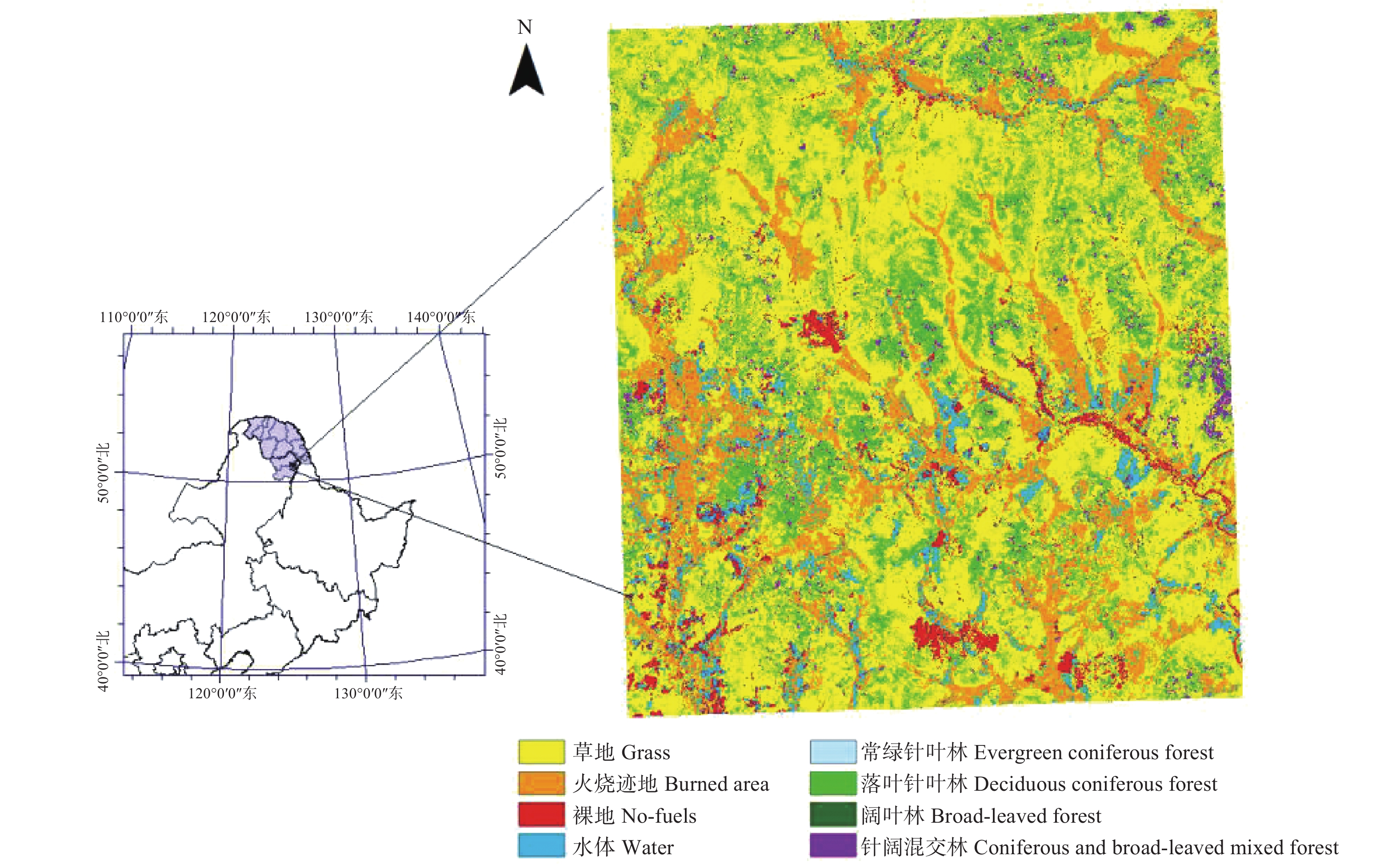
研究区地理范围125.131 9°~125.834 7° E,50.085 28°~51.056 11° N,总面积为215 550 hm2。该区域位于大兴安岭东南部,南瓮河国家自然保护区附近,隶属于松岭林业局(图1)。平均海拔为432 m。气候属寒温带大陆性季风气候,夏季短冬季长,年均气温−3 ℃,无霜期为90~100 d[23]。

图 1 研究区域和植被类型
Figure 1. The study area and vegetation types
研究区的乔木以兴安落叶松(Larix gmelinii(Rupr.)Kuzen.)、山杨(Populus davidiana Dode.)、白桦(Betula platyphylla Suk.)、黑桦(Betula dahurica Pall.)等为主,灌木有兴安杜鹃(Rhododendron dauricum L.)、越桔(Vaccinium vitisidaea Linn.)等,草本植物以杜香(Ledum palustre L.)和苔藓为主[24]。
-
遥感数据采用2016年5月13日的SPOT6卫星影像(分辨率6.6 m)。数字高程数据(分辨率为30 m)源于地理空间数据云(http://www.gscloud.cn/)。气象数据源于黑龙江省南瓮河国家自然保护区森林生态系统定位观测研究站,包括气温、降水量、日相对湿度、风速和风向等定时数据。森林火灾统计资料(1988—2016年)源于黑龙江省森林防火办公室,包括火点经纬度、火因、过火面积和扑救时间等信息。
-
基于每日中午(12:00)观测的温度、湿度、风速和过去24 h降水量,利用R软件cffdr程序包计算火险期内每日的火险天气指数(Fire Weather Index,FWI)[25],系统输出的指数包括细小可燃物湿度码(Fine Fuel Moisture Code,FFMC)、腐殖质湿度码(Duff Moisture Code,DMC)和干旱码(Drought Code,DC),初始蔓延速率(Initial Spread Index,ISI)和累积指数(Buildup Index,BI),以及火险天气指数(Fire Weather Index,FWI)[26]。计算时段是2016年整个火险期(3月1日—10月31日),FFMC、DMC和DC的初始值分别为85.0、6.0和15.0[27]。
-
火险期前计划火烧处理的区域主要是区域内的沟塘草甸。通过对卫星遥感影像处理,提取计划火烧的区域。首先利用ENVI软件RPC模型对SPOT6卫星影像进行正射校正,然后利用FLAASH模型进行大气校正。选择近红外、红外、绿3种波段合成图像,采用监督分类法提取计划火烧区域[28]。
-
通过实地调查,将区域内的可燃物分为草地、常绿针叶林、落叶针叶林、落叶阔叶林和针阔混交林5种类型。分类主要采用ENVI软件中的监督分类法。首先根据野外调查将影像中的地物进行识别,划定5种类型可燃物、裸地及水体,然后通过最大似然法(Maximum Likelihood Classification)进行分类,再通过Combine classes进行分类后处理,将类型一致的地物进行合并,获得可燃物分类图。并按照FBP(火行为预测)可燃物分类系统,用系统识别的代号表示各可燃物:草地(O-1a)、常绿针叶林(C-4)、落叶针叶林(M-1a)、落叶阔叶林(D-1)和针阔混交林(M-1b)。
-
BURN-P3模型需要输入的空间数据包括可燃物类型、地形及风向等,空间分辨率为100 m(ASC文本格式)[20]。风向数据利用WindNinja风场模拟软件处理[29]。该模型采用数字高程模型的单点风场,基于表面热通量、距离山谷底部或山脊顶部的距离、坡度及阻力等参数计算风向,模拟不同地形条件下风向[30]。利用研究区数字高程数据,结合该地区地面气象观测数据,计算该区域历史平均风速作为主导风速,为10 km·h−1,并划定北(0°)、东北(45°)、东(90°)、东南(135°)、南(180°)、西南(225°)、西(270°)和西北(315°)8个主要风场数据。
BURN-P3模型输入火因、燃烧日时长、蔓延天数、火险天气数据和模拟季节等运行参数。根据1988—2016年火灾统计资料,研究区人为火、雷击火发生概率分别为43.51%、56.49%,设置不同季节发生火灾的日燃烧时长以及该区域火灾发生的蔓延天数。火险天气数据包括正午的温度、湿度、风速、风向、过去24 h降水量以及对应的火险天气指数。
根据物候观测记录确定季节划分日期。草本和灌木多于3月中上旬展叶,兴安落叶松展叶盛期为5月24日,白桦等阔叶树展叶盛期为5月20日—5月26日,9月上旬落叶松开始落叶[31],大兴安岭南部植被展叶期更早[32-33]。因此,将研究时段划分为春季(3月1日—5月31日)、夏季(6月1日—8月31日)和秋季(9月1日—10月31日)。
-
将火烧迹地分为草地和无可燃物两种类型,以表示未进行计划火烧和已进行计划火烧两种情景,并分别进行燃烧模拟,其他参数保持一致,对比计划火烧处理前后的区域燃烧性。根据实测数据结合ArcGIS随机在火烧迹地选择100个点,分析计划火烧影响范围。
根据历史火灾统计资料,过火面积小于1 hm2次数占总次数的62.76%,结合研究区面积设定模拟中最小过火面积为1 hm2。为获取稳定的燃烧概率分布图,迭代次数为20 000次[34]。输出燃烧概率、火烧强度、蔓延速度、树冠火比例等空间数据和每次迭代的属性表(文本格式)。
-
根据卫星遥感数据提取的在2016年火险期前的计划火烧面积为44 931 hm2,占研究区总面积的20.8%(图2)。大部分过火区的地表土壤裸露,草本可燃物的地上部分基本消失,易燃可燃物很少,只有很少的区域残留少量草本和灌木。计划火烧处理过的区域不能支持火的持续燃烧和蔓延,因此,我们把计划火烧过的区域视为无可燃物。基于计划火烧前后的可燃物变化,分别模拟这两种可燃物情景下的森林燃烧概率,评估一个区域内的计划火烧处理对区域的森林燃烧性影响。
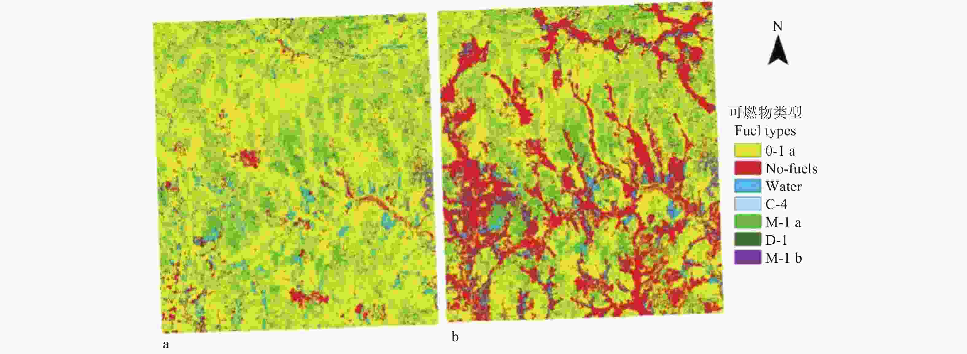
图 2 计划火烧区和模拟的两种可燃物情景
Figure 2. Prescribed burning areas and the two fuel scenarios for simulation.
-
未进行计划火烧情景下,研究区平均燃烧概率为0.016 4(燃烧概率范围为0~0.06)(图3a)。按照相等间隔法将燃烧概率划分为:低(0~0.017 5)、较低(0.017 5~0.035)、较高(0.035~0.0525)和高(0.052 5~0.07)4个等级,分别占区域总面积的46.3%、48.2%、5%和0.5%。沟塘草甸区域燃烧概率低,落叶针叶林区域燃烧概率高。
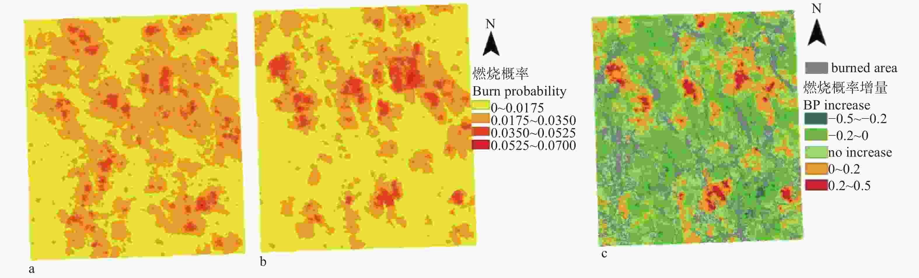
图 3 不同可燃物情景的燃烧概率及其变化
Figure 3. Burn probability and their changes for two fuel scenarios
计划火烧处理后,研究区平均燃烧概率为0.012 4(变化范围为0~0.07)(图3b),其中燃烧概率低、较低、较高和高的区域分别占区域总面积的61.7%、31.4%、6.3%和0.6%。中部落叶针叶林和混交林燃烧概率高。
经过计划火烧处理,研究区平均燃烧概率下降24.4%。计划火烧处理区域周围2 561.8 m范围内的燃烧概率下降(95%置信区间:2 323.3 ~2 800.3 m),燃烧概率降低的区域占总面积的43.8%。35.1%的区域的燃烧概率没有变化,21.1%区域的燃烧概率稍有增高。燃烧概率的变化主要是由于可燃物空间分布的变化引起的,由于多次迭代过程中火随机发生的位置和火险天气的变化,导致森林分布区域的燃烧概率发生变化,与计划火烧处理区域相邻的大部分区域的燃烧概率明显降低,部分落叶松林和混交林区域的燃烧概率升高,但区域内整体平均燃烧概率明显降低。
-
两种情景下,燃烧概率最高的可燃物类型都是落叶针叶林,其次为常绿针叶林、针阔混交林和草地,落叶阔叶林的燃烧概率最低(表1)。未进行计划火烧的情景下,落叶针叶林平均燃烧概率为0.023 6,常绿针叶林、针阔混交林、草地和落叶阔叶林平均燃烧概率分别为0.022 8、0.021 9、0.017 2和0.017。计划火烧处理后,落叶针叶林平均燃烧概率为0.022 6,降低4.2%,常绿针叶林、针阔混交林、草地和落叶阔叶林平均燃烧概率分别为0.022、0.020 6、0.016 8和0.016 9,分别降低3.5%、5.9%、2.3%和0.6%。
表 1 两种情景下可燃物类型及燃烧概率
Table 1. Burn probability for each fuel type with two scenarios
类型
Fuel types未进行计划火烧情景
Scenario without
prescribed burning
treatment计划火烧后情景
Scenario after
prescribed burning
treatment增量
Increase/
%草地(O-1a)
Grass0.017 2 0.016 8 −2.3% 常绿针叶林(C-4)
Evergreen coniferous forest0.022 8 0.022 −3.5% 落叶针叶林(M-1a)
Deciduous coniferous forest0.023 6 0.022 6 −4.2% 阔叶林(D-4)
Broad-leaved forest0.017 0.016 9 −0.6% 针阔混交林(M-1b)
Coniferous and broad-leaved forest0.021 9 0.020 6 −5.9% -
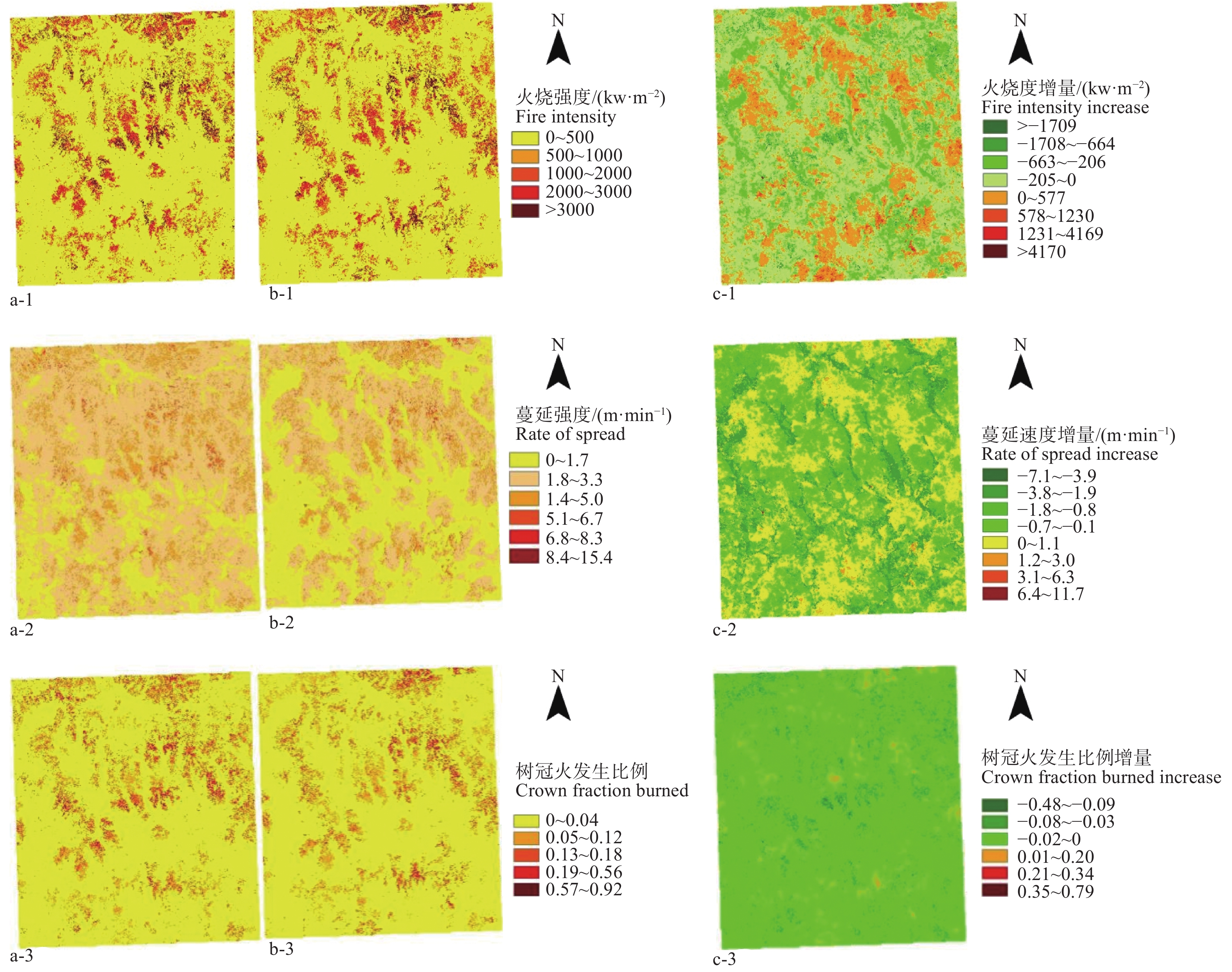
未进行计划火烧情景下,研究区平均火烧强度为548.9 kW(范围:0~6 356.5 kW·m−2)(图4a-1)。落叶松林和常绿针叶林区域平均火强度分别为3 451.8 kW·m−2和2 688 kW·m−2,而草类可燃物的平均火强度只有225 kW·m−2。计划火烧处理后,研究区平均火烧强度为450.6 kW·m−2(范围:0~13 204.5 kW·m−2),下降了17.9%(图4b-1)。89.8%的区域面积的火烧强度下降,只有10.2%的区域的火强度升高。草地和计划火烧区周围森林的火强度下降明显。
图 4 两种可燃物情景下的火行为变化
Figure 4. Changes of fire behavior under the two fuel scenarios
未进行计划火烧情景下,研究区平均蔓延速度为2.2 m·min−1(范围:0~8.3 m·min−1)(图4a-2)。草地的平均蔓延速度为2.1 m·min−1,落叶针叶林区域的蔓延速度为5.2 m·min−1。计划火烧处理后,整个区域的平均蔓延速度为1.6 m·min−1(范围:0~15.4 m·min−1),降低了27.3%。蔓延速度下降、不变和上升的区域分别占总区域面积的76.2%、3.9%和19.9%(图4b-2)。
落叶针叶林和针阔混交林容易发生树冠火。未进行计划火烧处理的情景下,树冠火平均发生比例为0.018 4(变化范围:0~0.56),落叶松和混交林区域树冠火发生比例分别为0.241 9和0.135 9(图4a-3)。计划火烧处理后,树冠火平均发生比例为0.016 2(变化范围:0~0.92),下降了11.7%。树冠火发生比例下降和不变的区域占总面积的94.8%,只有5.2%的区域树冠火发生比例上升(图4b-3)。虽然计划火烧处理的区域主要是草类可燃物,但整个区域的可燃物空间分布的变化会影响到整个区域的火行为特征,树冠火的发生比例也明显降低。
计划火烧处理后,落叶松林的火强度、蔓延速度和树冠火发生比例分别下降8.1%、5.8%和8.6%,针阔混交林的火强度、蔓延速度和树冠火发生比例分别下降5.3%、5%和15.0%,草地的火强度和蔓延速度分别下降7.9%和4.8%(表2)。
表 2 两种情景下各类型可燃物火行为
Table 2. Fire behavior for each fuel type with two scenarios
类型
Type未进行计划火烧情景
Scenario without prescribed
burning treatment进行计划火烧情景
Scenario after prescribed
burning treatment火行为增量
Fire behavior increase火强度
Fire intensity/
(kW·m−2)蔓延速度
Rate of spread/
(m·min−1)树冠火
发生比例
Crown fraction
burned火强度
Fire intensity/
(kW·m−2)蔓延速度
Rate of spread/
(m·min−1)树冠火
发生比例
Crown fraction
burned火强度增量
Fire intensity
increase蔓延速度增量
Rate of spread
increase树冠火发生
比例增量
Crown fraction
burned increase草地(O-1a)
Grass225 2.1 0 207.3 2.0 0 −7.9% −4.8% 0% 常绿针叶林(C-4)
Evergreen coniferous forest2 688.0 4.1 0.135 9 2 515.3 3.9 0.120 7 −6.4% −4.9% −11.2% 落叶针叶林(M-1a)
Deciduous coniferous forest3 451.8 5.2 0.242 0 3 171.3 4.9 0.221 2 −8.1% −5.8% −8.6% 阔叶林(D-4)
Broad-leaved forest291.1 1.0 0.001 8 259.3 0.9 0.001 5 −10.9% −10% −16.7% 针阔混交林(M-1b)
Coniferous and broad-leaved forest794.2 2.0 0.002 1 752.2 1.9 0.001 8 −5.3% −5% −15.0% -
BURN-P3模型是模拟长时间尺度上的火发生及蔓延过程,代表一个时段内林火动态变化。自1987年大兴安岭森林大火后,该区域的林火管理机构逐渐完善,林火管理政策基本稳定,因此,本研究选取1988—2016年的平均林火动态指标作为森林燃烧模拟的输入因子,基于一个相对稳定时段的平均火发生状态进行模拟不同可燃物情景下的森林燃烧概率及火行为,可以反映不同情景下的森林燃烧性状况,可以避免个别年份的极端情况的影响。因为提取的计划火烧区是2016年火险期前的处理情况,所以,模拟了2016年的火天气条件下的森林燃烧性,定量评估计划烧除对于区域森林燃烧性的影响。
计划火烧处理后,部分区域落叶松林树冠火比例增大,火强度升高。这是因为BURN-P3模型随机选择火点燃烧位置,并根据可燃物类型和火天气条件确定火是否蔓延。计划火烧处理区域主要在草类可燃物,处理后草类可燃物面积显著减少,但针叶林区域面积没有变化,它占的面积比例有所增加,所有模拟中针叶林被点燃的比例增大。模拟中采用1988—2016年的空间发生概率,20 000次迭代模拟可以消除绝大部分的误差,模拟结果稳定、可靠。
研究区内一些落叶松林内存在大量易燃可燃物及可燃物梯,易形成树冠火。如果利用人工或机械措施清理这类可燃物的可燃物梯,或者通过低强度计划火烧清理地表细小可燃物,森林燃烧性会进一步降低,树冠火发生比例也会进一步减少。相关研究也表明降低地表可燃物载量可以减少林火的发生。刘志华等[7]认为计划火烧可以在一定程度上减少潜在的森林火灾面积。Shang等[35]利用LANDIS模拟了计划火烧处理后硬木阔叶林的火险变化,认为计划火烧结合粗大可燃物的处理可降低森林火险。
-
火险期前对一个区域内的草类可燃物进行计划火烧处理,能有效降低区域内森林的燃烧性。计划火烧处理区域附近2 561.8 m范围内的森林燃烧性明显降低。计划火烧后整个区域的平均燃烧概率降低了24.4%,火强度、蔓延速度及树冠火比例分别降低17.9%、24.3%及11.7%。各类型可燃物燃烧概率较计划火烧前均呈下降趋势,其中落叶针叶林和混交林燃烧概率分别降低5.9%和4.2%。与计划火烧前相比,火烧后各类型可燃物火行为均降低,阔叶林和落叶针叶林降幅明显。证明计划火烧是预防一个区域发生森林大火和降低森林燃烧性的有效措施。
计划火烧对区域森林燃烧性的影响
Influences of Prescribed Burning on Regional Forest Burning Probability
-
摘要:
目的 利用燃烧概率模型模拟计划火烧前后两种情景下的森林燃烧概率,在景观尺度上定量评估计划火烧在林火预防中的作用。 方法 利用SPOT6卫星数据提取大兴安岭部分区域在2016年火险期前进行计划火烧处理的可燃物状况,基于研究区附近地面气象观测数据利用R软件计算2016年火险期每日的火险指数,通过BURN-P3模型分别模拟计划火烧前后的森林燃烧性,评估计划火烧对森林燃烧概率和火行为的影响。 结果 2016年火险期前该区域进行计划火烧的面积为44 931 hm2,占区域总面积的20.8%。计划火烧后,研究区平均燃烧概率从0.016 4降到0.012 4,落叶针叶林、常绿针叶林、针阔混交林、草地和落叶阔叶林平均燃烧概率分别降低4.2%、3.5%、5.9%、2.3%和0.6%。计划火烧前研究区的平均火烧强度和平均蔓延速度分别为548.9 kW·m−2和2.2 m·min−1,通过计划火烧处理,火烧强度和蔓延速度分别降低17.9%和24.3%。落叶针叶林和针阔混交林是发生树冠火的主要类型,火强度高、火蔓延速度快。计划火烧处理后研究区的树冠火比例降低了11.7%。 结论 火险期前的计划火烧减少了区域内草类可燃物的空间分布,降低了草类可燃物载量,也有效降低了区域内的森林燃烧性,平均火强度、蔓延速度和树冠火发生比例均显著降低。计划火烧区附近2 500 m范围内的燃烧概率明显降低。 Abstract:Objective Burning probability model was used to simulate fire burning on the landscape scale and the impacts of prescribed burning on forest flammability were assessed quantitatively. Method The data about fuel conditions of some areas of Daxing’anling after prescribed burning before the fire season of 2016 were extracted from SPOT6 satellite data. The daily weather indices in the fire season were calculated with the weather observation data near the study area by using R-software. The burning probability and fire behavior indices of the forest were simulated with BURN-P3 model for the scenarios with and without prescribed burning. Result The areas treated with prescribed burning in 2016 were 44,931 hm2, accounting for 20.8% of the total area. The average burning probability was 0.0164 and 0.0124 for the scenarios with and without prescribed burning. The average burning probability for each fuel type respectively decreased by 4.2% for deciduous coniferous forest, 3.5% for evergreen coniferous forest, 5.9% for coniferous and broad-leaved mixed forest, 2.3%for grass, and 0.6% for broad-leaved forest after prescribed burning. The average fire intensity and spread speed were 548.9 kW/m2 and 2.2 m/min under the scenario with prescribed burning. The average fire intensity and spread rate decreased by 17.9% and 24.3% due to prescribed burning. Deciduous coniferous forests and mixed forest showed high fire intensity and spread speed, and are easy to occur crown fires. The proportion of crown fire reduced by 11.7% after prescribed burning. Conclusion The prescribed burning could decrease the distribution areas of grass fuel and fuel loadings. The burn probability, fire intensity, rate of spread and crown fire fraction of the region decrease after prescribed burning. The burning probability will drop obviously in the buffer areas with 2500 m wide around the prescribed burning regions. -
Key words:
- prescribed burning
- / burn probability model
- / forest combustibility
- / Daxing’anling
-
图 2 计划火烧区和模拟的两种可燃物情景
Figure 2. Prescribed burning areas and the two fuel scenarios for simulation.
图 3 不同可燃物情景的燃烧概率及其变化
Figure 3. Burn probability and their changes for two fuel scenarios
表 1 两种情景下可燃物类型及燃烧概率
Table 1. Burn probability for each fuel type with two scenarios
类型
Fuel types未进行计划火烧情景
Scenario without
prescribed burning
treatment计划火烧后情景
Scenario after
prescribed burning
treatment增量
Increase/
%草地(O-1a)
Grass0.017 2 0.016 8 −2.3% 常绿针叶林(C-4)
Evergreen coniferous forest0.022 8 0.022 −3.5% 落叶针叶林(M-1a)
Deciduous coniferous forest0.023 6 0.022 6 −4.2% 阔叶林(D-4)
Broad-leaved forest0.017 0.016 9 −0.6% 针阔混交林(M-1b)
Coniferous and broad-leaved forest0.021 9 0.020 6 −5.9%  下载: 导出CSV
表 2 两种情景下各类型可燃物火行为
Table 2. Fire behavior for each fuel type with two scenarios
类型
Type未进行计划火烧情景
Scenario without prescribed
burning treatment进行计划火烧情景
Scenario after prescribed
burning treatment火行为增量
Fire behavior increase火强度
Fire intensity/
(kW·m−2)蔓延速度
Rate of spread/
(m·min−1)树冠火
发生比例
Crown fraction
burned火强度
Fire intensity/
(kW·m−2)蔓延速度
Rate of spread/
(m·min−1)树冠火
发生比例
Crown fraction
burned火强度增量
Fire intensity
increase蔓延速度增量
Rate of spread
increase树冠火发生
比例增量
Crown fraction
burned increase草地(O-1a)
Grass225 2.1 0 207.3 2.0 0 −7.9% −4.8% 0% 常绿针叶林(C-4)
Evergreen coniferous forest2 688.0 4.1 0.135 9 2 515.3 3.9 0.120 7 −6.4% −4.9% −11.2% 落叶针叶林(M-1a)
Deciduous coniferous forest3 451.8 5.2 0.242 0 3 171.3 4.9 0.221 2 −8.1% −5.8% −8.6% 阔叶林(D-4)
Broad-leaved forest291.1 1.0 0.001 8 259.3 0.9 0.001 5 −10.9% −10% −16.7% 针阔混交林(M-1b)
Coniferous and broad-leaved forest794.2 2.0 0.002 1 752.2 1.9 0.001 8 −5.3% −5% −15.0%
下载: 导出CSV
-
[1] Finney M A, McHugh C W, Grenfell I C. Stand-and landscape-level effects of prescribed burning on two Arizona wildfires[J]. Canadian Journal of Forest Research, 2005, 35(7): 1714-1722. doi: 10.1139/x05-090 [2] Biswell H H. Prescribed burning[D]. State of California: University of California, 1989. [3] Finney M A, Seli R C, McHugh C W, et al. Simulation of long-term landscape-level fuel treatment effects on large wildfires[J]. International Journal of Wildland Fire, 2008, 16(6): 712-727. [4] Faivre N, Boudreault C, Renard S, et al. Prescribed burning of harvested boreal black spruce forests in eastern Canada: effect on understory vegetation[J]. Canadian Journal of Forest Research, 2016, 46(6): 876-884. doi: 10.1139/cjfr-2015-0439 [5] 马爱丽, 李小川, 王振师, 等. 计划火烧的作用与应用研究综述[J]. 广东林业科技, 2009, 25(6):95-99. [6] 舒立福, 田晓瑞, 寇晓军. 计划火烧的应用与研究[J]. 火灾科学, 1998(3):62-68. [7] 刘志华, 常 禹, 贺红士, 等. 模拟不同森林可燃物处理对大兴安岭潜在林火状况的影响[J]. 生态学杂志, 2009, 28(8):1462-1469. [8] 赵彬清, 胡同欣, 李 飞, 等. 计划火烧对阿里河兴安落叶松林土壤呼吸影响[J]. 森林工程, 2018, 34(4):21-26. doi: 10.3969/j.issn.1006-8023.2018.04.004 [9] Agee J K, Skinner C N. Basic principles of forest fuel reduction treatments[J]. Forest Ecology and Management, 2005, 211(1-2): 83-96. doi: 10.1016/j.foreco.2005.01.034 [10] Bradstock R A, Bedward M, Cohn J S. The modelled effects of differing fire management strategies on the conifer Callitris verrucosa within semi-arid mallee vegetation in Australia[J]. Journal of Applied Ecology, 2006, 43(2): 281-292. doi: 10.1111/j.1365-2664.2006.01142.x [11] Progar R A, Hrinkevich K H, Clark E S, et al. Prescribed burning in ponderosa pine: fuel reductions and redistributing fuels near boles to prevent injury[J]. Fire Ecology, 2017, 13(1): 149. doi: 10.4996/fireecology.1301149 [12] Keane R E. Biophysical controls on surface fuel litterfall and decomposition in the northern Rocky Mountains, USA[J]. Canadian Journal of Forest Research, 2008, 38(6): 1431-1445. doi: 10.1139/X08-003 [13] 王秋华, 单保君, 龚家平, 等. 滇中地区云南松纯林计划火烧研究[J]. 江西农业大学学报, 2018, 40(2):235-240. [14] He H S. Forest landscape models: definitions, characterization, and classification[J]. Forest Ecology and Management, 2008, 254(3): 484-498. doi: 10.1016/j.foreco.2007.08.022 [15] Andrews P L, Queen L L P. Fire modeling and information system technology[J]. International Journal of Wildland Fire, 2001, 10(4): 343-352. doi: 10.1071/WF01033 [16] Clinton N E, Gong P, Scott K. Quantification of pollutants emitted from very large wildland fires in Southern California, USA[J]. Atmospheric Environment, 2006, 40(20): 3686-3695. doi: 10.1016/j.atmosenv.2006.02.016 [17] Chew J D, Stalling C, Moeller K. Integrating knowledge for simulating vegetation change at landscape scales[J]. Western Journal of Applied Forestry, 2004, 19(2): 102-108. doi: 10.1093/wjaf/19.2.102 [18] Shang Z B, He H S, Lytle D E, et al. Modeling the long-term effects of fire suppression on central hardwood forests in Missouri Ozarks, using LANDIS[J]. Forest Ecology and Management, 2007, 242(2-3): 776-790. doi: 10.1016/j.foreco.2007.02.026 [19] Parisien M A, Miller C, Ager A A, et al. Use of artificial landscapes to isolate controls on burn probability[J]. Landscape Ecology, 2010, 25(1): 79-93. doi: 10.1007/s10980-009-9398-9 [20] Wang X, Parisien M A, Taylor S W, et al. Future burn probability in south-central British Columbia[J]. International Journal of Wildland Fire, 2016, 25(2): 200-212. doi: 10.1071/WF15091 [21] Ye T, Wang Y, Guo Z, et al. Factor contribution to fire occurrence, size, and burn probability in a subtropical coniferous forest in East China[J]. PloS one, 2017, 12(2): e0172110. doi: 10.1371/journal.pone.0172110 [22] 苗庆林, 田晓瑞. 多气候情景下大兴安岭森林燃烧性评估[J]. 林业科学, 2016, 52(10):109-116. doi: 10.11707/j.1001-7488.20161014 [23] 刘 盼, 任春颖, 王宗明, 等. 南瓮河自然保护区生态环境质量遥感评价[J]. 应用生态学报, 2018, 29(10):3347-3356. [24] 任健滔, 王宏燕. 南瓮河自然保护区的综合评价[J]. 安徽农业科学, 2012, 40(18):9840-9842. doi: 10.3969/j.issn.0517-6611.2012.18.096 [25] Wang X, Wotton B M, Cantin A S, et al. Cffdrs: an R package for the Canadian forest fire danger rating system[J]. Ecological Processes, 2017, 6(1): 5. doi: 10.1186/s13717-017-0070-z [26] Stocks B J, Lynham T J, Lawson B D, et al. Canadian forest fire danger rating system: an overview[J]. The Forestry Chronicle, 1989, 65(4): 258-265. doi: 10.5558/tfc65258-4 [27] Van Wagner C E. Development and structure of the Canadian forest fire weather index system[M]. Ottawa: Canadian Forestry Service, 1987. [28] 高中灵, 汪小钦, 周小成. 火烧迹地信息遥感快速提取方法研究[J]. 国土资源遥感, 2005(4):38-41+88. doi: 10.3969/j.issn.1001-070X.2005.04.009 [29] Wagenbrenner N S, Forthofer J M, Lamb B K, et al. Downscaling surface wind predictions from numerical weather prediction models in complex terrain with WindNinja[J]. Atmospheric Chemistry and Physics, 2016, 16(8): 5229-5241. doi: 10.5194/acp-16-5229-2016 [30] Sanjuan G, Brun C, Margalef T, et al. Wind field uncertainty in forest fire propagation prediction[J]. Procedia Computer Science, 2014, 29: 1535-1545. doi: 10.1016/j.procs.2014.05.139 [31] 中国科学院地理研究所. 中国动植物物候观测年报第11号[M]. 北京: 中国科学技术出版社, 1992. [32] 国志兴, 张晓宁, 王宗明, 等. 东北地区植被物候对气候变化的响应[J]. 生态学杂志, 2010, 29(3):578-585. [33] 浮媛媛, 赵建军, 张洪岩, 等. 基于生态地理分区的大兴安岭植被物候时空变化[J]. 应用生态学报, 2016, 27(9):2797-2806. [34] Parisien M A, Junor D R, Kafka V G. Comparing landscape-based decision rules for placement of fuel treatments in the boreal mixedwood of western Canada[J]. International Journal of Wildland Fire, 2008, 16(6): 664-672. [35] Shang B Z, He H S, Crow T R, et al. Fuel load reductions and fire risk in central hardwood forests of the United States: a spatial simulation study[J]. Ecological Modelling, 2004, 180(1): 89-102. doi: 10.1016/j.ecolmodel.2004.01.020 -

 点击查看大图
图(4) / 表(2)
计量
- 文章访问数: 5852
- HTML全文浏览量: 3028
- PDF下载量: 108
- 被引次数: 0
